The Railroad Survey


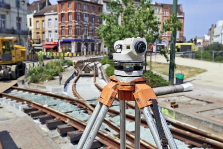
Railroad surveys are those surveys that are performed within or near rail yards or railway corridors.  Railroad surveys differ from those performed in connection with highways and utilities because the surveyor has to use different techniques and, sometimes, different equipment to perform a railroad survey.  Just as with any survey, railroad surveys differ greatly depending on the project.


Railroad Track Profiles and Topographic Surveys


Railroad track profiles and topographic surveys deal with slope, curve and grade of the track and its surrounding areas.  These surveys are needed when new tracks are to be built, or when construction is being done that affects the use of the tracks, such as a new bridge, tunnel, or road that will cross the tracks.  These surveys will include features found on most surveys, plus some that are unique to railroad surveys:


  • Location of existing track centerlines
  • Gage— the distance between the rails. There is a standard gage for North American railroad tracks (4’ 8.5”) that allows rail cars to run on any track on the continent.
  • Existing Rail Section
  • Milepost Reference
  • Right-of-Way Width
  • Location of switches, bumping posts, derails
  • Terminals
  • Valuation Station Reference
  • Buildings
  • Roads
  • Fences
  • Culverts, bridges, or other types of drainage structures
  • Waterways
  • Utilities, both above and under ground


Right-of-Way Surveys


Railroad right-of-way surveys are unique types of surveys that harken back to surveying methods originated centuries ago.  These surveys use historical records and track curve data from railroad surveys completed long ago, to establish original right-of-way.  Right-of-way issues become important when easements are requested for installation of utilities such as gas pipelines, fiber optic cable, and electric power lines.


Railroad surveys come with their own unique challenges and the surveying team doing the job must be experienced and well trained.  If you need a survey on or around a rail yard or railroad, please contact Votex Surveying Company at 469-333-8831 for an estimate on your surveying project.


Keeping An Updated Survey


Whether you have just purchased a piece of property, are about to purchase one, or have had the title to it for a while, it’s important to make sure the survey is up to date. Therefore, there are several reasons why you would want to keep the survey up-to-date.

Reasons for an Updated Survey

Any time you plan to do anything with the land, you need to make sure the survey plat is completely updated. Alterations to the property (or to lands neighboring it), changes in ownership, making subdivisions, granting easements, and so forth all require a clear description of the property. This helps protect your investment and prevent lawsuits over property issues. For example:

  • If you’re purchasing the land, you don’t want any surprises due to changes that were not accounted for.
  • If you plan to develop the land, you need to know what is in your rights to do and have a clear marking of where the boundaries are. Certain locations may limit what you can do with your property.
  • If you are trying to sell the land, having a current survey will ensure you and your buyers know exactly what you are selling.
  • If neighboring property has been developed, it may impact the state of your land.

Any time you do something with the land, you should get the survey updated. Even if you are not planning anything any time soon, keeping an up-to-date survey in your records at all times is still beneficial. Changes made to neighboring plots of land, for example, could lead to issues down the line if they overstep their bounds. Having a current land survey will ensure your rights to your land are protected.

Updating Your Survey

If you’re looking to update a land title, construction, typography, elevation, or plat survey in the Dallas area, contact Votex Surveying Company today at (469) 333-8831.

Votex Surveying Company Launches New Website!

Welcome to our new website! Dedicated to providing the highest quality commercial surveys, we have continually invested in our technology to improve our approach in all types of surveys as well as ensure your experience is always efficient and stress free.

For over 25 years, Votex Surveying Company has established it’s reputation by imposing the industries highest standards when conducting a survey for your project. To insure each client receives the highest quality surveys, our surveyors are all certified, highly experienced, and stay up to date on the latest in the industry by attending seminars and trainings.

There are 6 main types of surveys:

• Elevation Certificate/LOMA
• Land Title Survey
• Boundary Survey
• ALTA/ACSM Title Survey
• Topography Surveying
• Builder Construction Survey

Still have more questions? The experts at Votex Surveying Company have the answers, don’t hesitate to call us today!